September 4, 2014 · Posted in: General
REBLOG: Satellite images as proof
This article was first published on PCIJ Founding Executive Director Sheila Coronel’s site Watchdog Watcher.
By Sheila S. Coronel
IN THE past week, three stories on three very different issues showed once again how satellite images, until recently confined to the weather report, are now the stuff of front-page news. All three are important stories with wide-ranging implications on public policy. But they also raise questions about the reliability of satellite imagery as proof and the ability of journalists – and their audiences – to make sense of them. Just like photographs, satellite images without context can distort the truth. And like photography, interpreting satellite imagery is as much art as it is science.
In recent years, there have been a number of journalistic projects that made good use of the wealth of satellite imagery, which is increasingly freely available. The 2006 project Vanishing Wetlands by the St. Petersburg Times, is a good, early example. Comparing satellite photos taken in the late 1980s and in 2003, the report showed how 84,000 acres of wetlands in Florida had vanished in the previous 15 years right under the noses of regulators tasked with protecting them. But the learning curve for using satellite images is steep, and for the most part, journalists have lagged behind other users, including NGOs, in making full use of them.
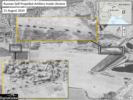
On Thursday, NATO released five satellite photos from an independent company called Digital Globe that purport to show Russian combat troops and artillery crossing into the Ukrainian border, contradicting Russian and Ukrainian separatist claims that no such incursions had taken place. The images are dated August 21, 2014, and they appear authentic, but most news reports published the photographs from the NATO press release without independently verifying their provenance or the reliability of the NATO interpretation. The best roundup was from the Washington Post, which pieced the images together with reports, videos and photos from the field in a story that asks a question without giving a definitive answer, “Has Russia invaded Ukraine? Here’s what we know.”
On the same day, August 28, the ninth anniversary of Hurricane Katrina, Pro Publica and the New Orleans nonprofit news site The Lens unveiled “Losing Ground,” an interactive map using satellite imagery that showed how nearly 2,000 square miles of coastal land in southeastern Louisiana had disappeared in the past 80 years as levees, canals and oil wells and pipelines were built. Given the current rate that the sea is rising and land sinking, the story said, most of southeastern Louisiana would be under water in 50 years.
In satellite imagery as elsewhere, our capacity to aggregate, analyze and interpret is outstripped by the quantity and speed of information being produced and made freely available. If anything, all these projects demonstrate the need for a new literacy in satellite imagery, not just for journalists or others in the information space but also for citizens who are likely going to be served more and more of these images as part of their daily diet of news.
READ ON AT SHEILA CORONEL’S WEBSITE


