
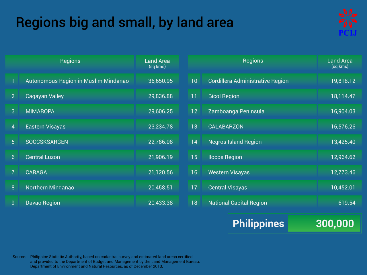
THE PHILIPPINES has a total land area of about 300,000 square kilometers (sq km).
This is according to the cadastral survey and estimated land areas certified and provided to the Department of Budget and Management by the Land Management Bureau, Department of Environment and Natural Resources, as of December 2013.
Nearly half or 43 percent consists of mainland Luzon and the islands of MIMAROPA), 40 percent Mindanao, and 17 percent the Visayas island group (Western, Central, and Eastern Visayas, and Negros Island).
LAND AREA
Among the proposed federated regions, the Autonomous Region in Muslim Mindanao (ARMM) will be the largest in terms of land area at 36,650.95 sq kms or 12.2 percent of the country’s total land area, while the National Capital Region is the smallest at 619.54 sq kms (0.21 percent).
By province, Palawan is the largest in terms of land area at 17,030.75 sq kms, followed by Lanao del Sur, 15,055.51 sq kms; Isabela, 13,102.05 sq kms; Bukidnon, 10,498.59 sq kms; and Agusan del Sur at 9,989.52sq kms.
Of the generally smaller island provinces, Batanes is the smallest, at 203.22 sq kms, followed by Camiguin, 241.44 sq kms; Siquijor, 337.49 sq kms; Biliran, 536.01 sq kms, and Guimaras, 611.87 sq kms.
Here’s how the regions rank, from biggest to smallest, by land area:
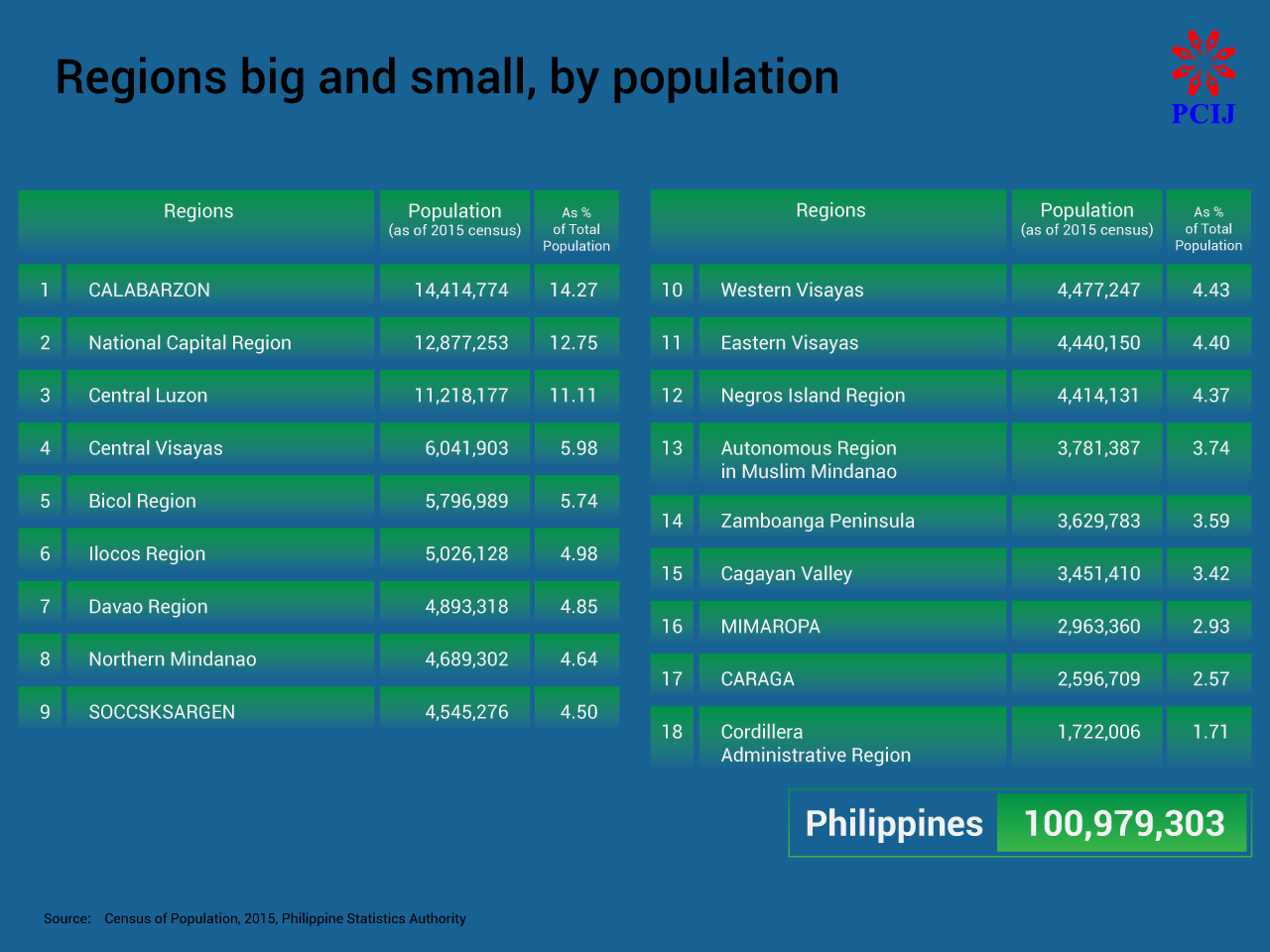
POPULATION
The Philippine population has reached more than 100 million, according to the 2015 Census of Population (POPCEN 2015) of the Philippine Statistic Authority.
Over half or 57 percent reside in Luzon, 23 percent in the Visayas, and 20 percent in Mindanao.
Under the proposed federal system, CALABARZON will be the largest federated region in terms of population, with 14 million people (14.3 percent of total population), while the Cordillera Administrative Region (CAR) will be the smallest with 1.7 million (1.71 percent).
Provinces with or near metropolitan areas usually have large populations. Cebu is currently the largest province in terms of population with 4.6 million people, followed by Cavite with 3.6 million; Bulacan, 3.2 million; Negros Occidental, 3.31 million; and Laguna, three million.
Batanes meanwhile is the smallest province in terms of population, with just 17,246 people, followed by Camiguin, 88,478; Siquijor, 95,984; Apayao, 119,184; and the Dinagat Islands, 127,152.
Here’s how the regions rank, from largest to smallest, by population:
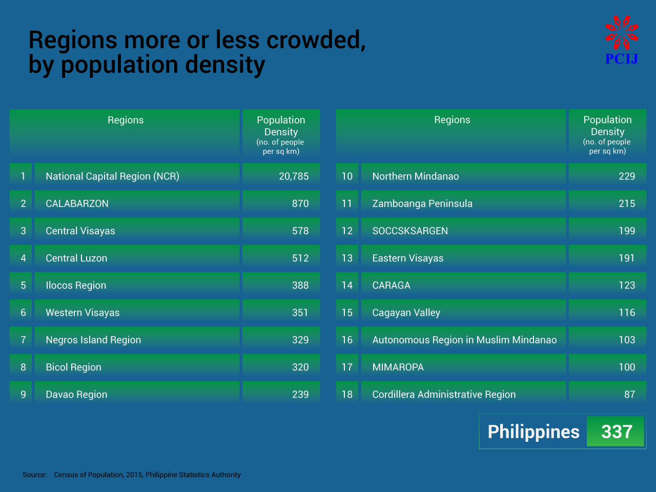
POPULATION DENSITY
The current national population density stands at 337 people per sq km.
Among the proposed federated regions, the National Capital Region (NCR) is the most densely populated with 20,785 people per sq km, while CAR is the least densely populated at 87 people per sq km.
Provinces with or near metropolitan areas are also some of the most densely populated: Rizal province has the highest population density at 2,439 people per sq km, followed by Cavite, 2,410 people per sq km,; Laguna, 1,574 people per sq km; Pampanga, 1,264 people per sq km; and Bulacan, 1,183 people per sq km.
Apayao is the least densely populated province with 26 people per sq km, followed by Abra at 57 people per sq km; and Kalinga, Mountain Province, and Palawan, all with 65 people per sq km.
Some regions are more crowded than others. Here’s how they rank, by population density:
POPULATION GROWTH RATE
The Philippine Statistics Authority (PSA) defines population growth rate as “how fast a population increases or decreases as a result of the interplay of births, deaths, and migration during a given period of time.”
By the data in POPCEN 2015, the provinces with the highest average annual population growth rates are Maguindanao at 4.4 percent; Cavite, 3.54 percent ; Basilan, 3.39 percent; Rizal, 3.03 percent; and Sulu, 2.8 percent.
The provinces with the lowest average annual population growth rates are the Mountain Province and Dinagat Islands, both at 0.05 percent; Abra, 0.54 percent; Marinduque, 0.58 percent; and Romblon, 0.62 percent.
LAND, POPULATION, POPULATION DENSITY STATS ON THE REGIONS
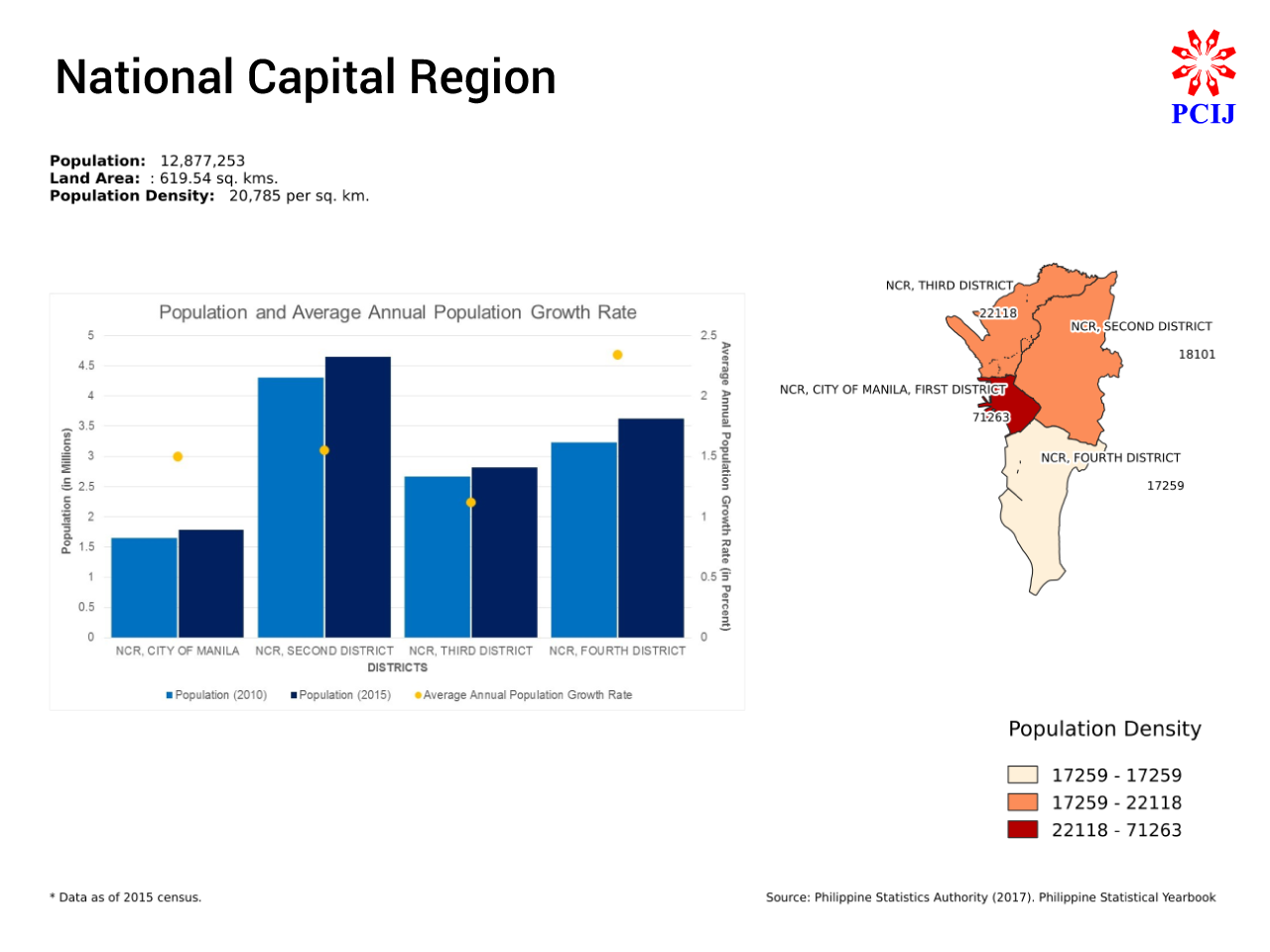
National Capital Region
Fast Facts (Rank among 18 regions):
Land Area: 619 sq km (No. 18)
Population: 12.88 million (Rank No. 2)
Population density: 20,785 persons per sq km (No. 1)
The National Capital Region (Metro Manila) will be assigned as the federal capital of the Philippines. For statistical purposes, PSA grouped the 17 cities and one municipality of NCR into four districts: 1st District, City of Manila; 2nd District, Mandaluyong City, Marikina City, Pasig City, Quezon City, and San Juan City; 3rd District, Caloocan City, Malabon City, Navotas City, and Valenzuela City; and 4th District, Las Pinas City, Makati City, Muntinlupa City, Paranaque City, Pasay City, Pateros, and Taguig City.
NCR will be the smallest federated region in terms of land area at 619.54 sq kms (0.21 percent of the country’s total population) but will have the second largest population at 12.9 million (12.8 percent of the country’s total population) as of POPCEN 2015. With a population density of 20,785 people per sq km, however, NCR will be the most densely populated region in the country.
NCR’s second district is the largest of NCR’s four districts in terms of land area, at 257 sq kms (41 percent of NCR’s total land area), followed by the fourth district at 210 sq kms (34 percent); the third district at 127 sq kms (21 percent); and the city of Manila at 25 sq kms (four percent).
NCR’s second district also has the largest population, with 4,650,613 people (36 percent of NCR’s total population), followed by the fourth district with 3,627,104 (28 percent); the third district with 2,819,388 (22 percent); and the city of Manila, 1,780,148 (14 percent). The second district’s population is even larger than that of Cebu, the most populous province in the country.
The district of the City of Manila is the most densely populated, however, with 71,263 people per sq km. It is followed by NCR’s third district at 22,118 people per sq km; the second district at 18,101 people per sq km; and the fourth district at 17,259 people per sq km.
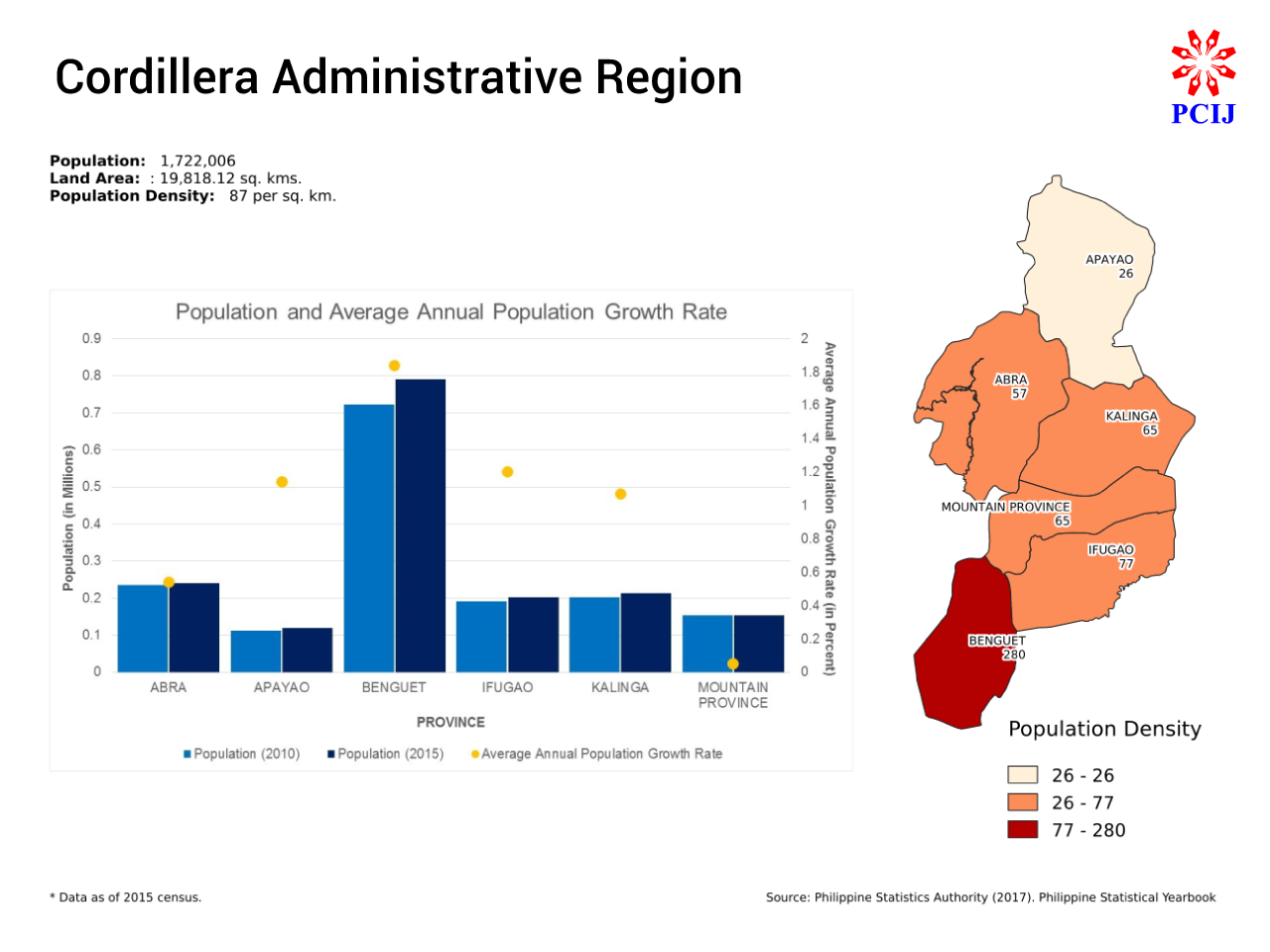
Cordillera Administrative Region
Fast Facts (Rank among 18 regions):
Land Area: 19,818 sq km (No. 10)
Population: 1.72 million (No. 18)
Population density: 87 persons per sq km (No. 18)
The Cordillera Administrative Region (CAR) will comprise the provinces of Abra, Benguet, Ifugao, Kalinga, Apayao, and Mountain Province.
It will be the ninth smallest federated region in terms of land area, with 19,818 sq kms (5.70 percent of the country’s total land area), and also the least populated, with 1,722,006 percent (1.71 percent of the country’s total population) as of POPCEN 2015.
With just 87 people per sq km, CAR will also be the least densely populated federated region. In fact, four of the least populated provinces in the country are in CAR: Apayao, Abra, Kalinga, and Mountain Province.
Apayao is the largest province in CAR in terms of land area, with 4,502 sq kms (23 percent of the region’s total land area), followed by Abra with 4,200 sq kms (23 percent); Kalinga 3,282 sq kms (17 percent); Benguet 2,827 sq kms (14 percent); Ifugao 2,618 sq kms (13 percent); and Mountain Province 2,389 sq kms (12 percent).
Benguet, however, has the largest population among the provinces in CAR, with 791,590 people (46 percent of the region’s total population). It is followed by Abra with 241,160 people (14 percent); Kalinga 21,680 (12 percent); Ifugao 202,802 (12 percent); Mountain Province 154,590 (nine percent); and Apayao 119,184 (seven percent) as of POPCEN 2015.
Almost half of CAR’s total population live in Benguet, the region’s third smallest province. This makes it the most densely populated province in the region, with 280 people per sq km, or almost thrice the region’s population density. Ifugao ranks second, at 77 people per sq km, followed by Kalinga and Mountain Province, both with population densities of 65 people per sq km, and then Abra at 57 people per sq km. Apayao is the least densely populated province, not just in CAR but also in the whole country, at 26 people per sq km.
Benguet has the highest average annual population growth rate in CAR as well, at 1.84 percent, followed by Ifugao at 1.2 percent; Apayao at 1.14 percent; and Kalinga at 1.07 percent. Mountain Province has the lowest average annual population growth rate, not just in CAR but also in the whole country, at 0.05 percent, while Abra has the second lowest, at 0.54 percent.
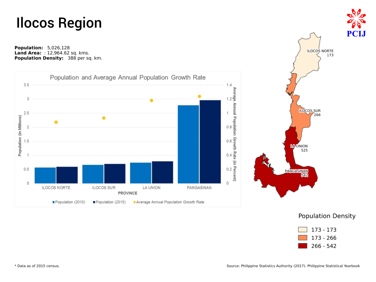
Ilocos Region
Fast Facts: (Rank among 18 regions)
Land Area: 12,964 sq km (No. 15)
Population: 5.03 million (No. 6)
Population density: 388 persons per sq km (No. 5)
The Federated Region of Ilocos will comprise the current provinces of Region I: Ilocos Norte, Ilocos Sur, La Union, and Pangasinan. It will be the fourth smallest federated region in terms of land area, with 12,964.62 sq kms (3.73 percent of the country’s total land area) and the sixth largest in terms of population, at 5,026,128 (4.98 percent of the country’s total population) as of POPCEN 2015. Ilocos Region ranks fifth in terms of population density, with 388 people per sq km.
Pangasinan is the largest province in the proposed federated region of Ilocos in terms of land area, with 5,450.59 sq kms (42 percent of Ilocos’s total land area), followed by Ilocos Norte with 3418.75 sq kms (26 percent); Ilocos Sur 2,596 sq kms(14 percent), and La Union 1,499.28 sq kms (12 percent).
Pangasinan is also the largest province in terms of population, with 2,956,726 people (59 percent of Ilocos’s total population), followed by La Union with 786,653 (16 percent); Ilocos Sur with 689,668 (14 percent); and Ilocos Norte with 593,081 (12 percent) as of POPCEN 2015.
Almost 60 percent of Ilocos’s population occupy only 40 percent of the region’s land area. Pangasinan is the most densely populated province in Ilocos, at 542 people per sq km, followed by La Union at a close 525 people per sq km; Ilocos Sur at 266 people per sq km; and Ilocos Norte at 173 people per sq km.
Pangasinan has the highest average annual population growth rate in the Ilocos Region at 1.24 percent, followed by La Union at 1.18 percent; Ilocos Sur at 0.93 percent; and Ilocos Norte at 0.87 percent.
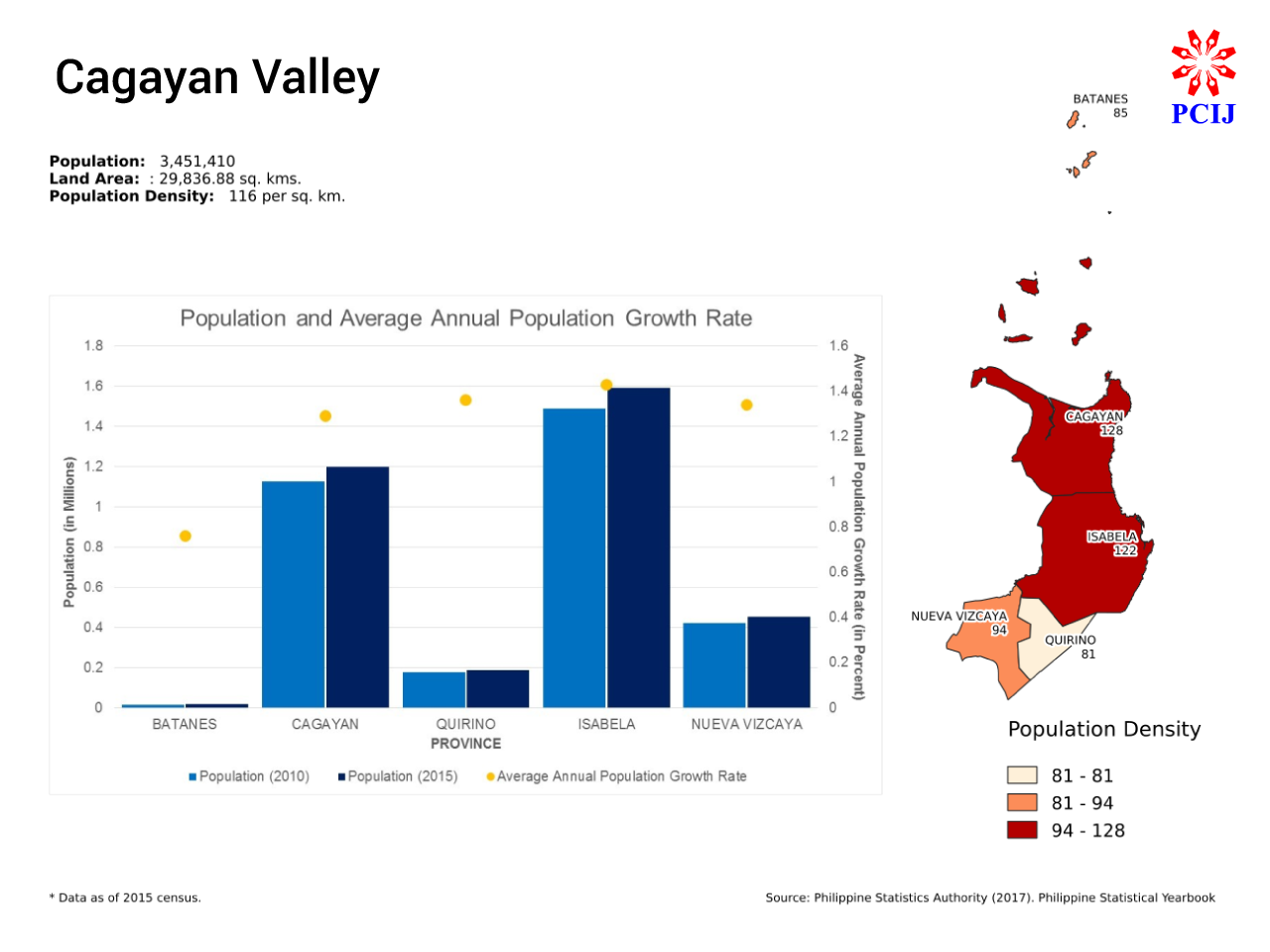
Cagayan Valley
Fast Facts (Rank among 18 regions):
Land Area: 19,818 sq km (No. 10)
Population: 3.45 million (No. 15)
Population density: 116 persons per sq km (No. 15)
The Federated Region of Cagayan Valley will comprise the current provinces of Region II: Batanes, Cagayan, Isabela, Neuva Vizcaya, and Quirino.
It will be the second largest federated region with 29,836.88 sq kms (8.58 percent of the country’s total land area) and the fourth smallest in terms of population, with 3,451,410 people (3.42 percent of the country’s total population) as of POPCEN 2015. Cagayan Valley ranks 15th in terms of population density, at 116 people per sq km.
Isabela is the largest province in the proposed federated region of Cagayan Valley in terms of land area, with 13,102.05 sq kms (44 percent of the region’s total land area), followed by Cagayan with 9,398.07 sq kms (31 percent); Nueva Vizcaya with 4,813.88 sq kms (16 percent), and Quirino with 2,319.66 sq kms (8 percent).
The province of Batanes, located in the group of islands north of mainland Luzon, is the smallest province not only in Cagayan Valley, but also in the entire Philippines, with 203.22 sq kms (1 percent of the region’s total land area).
Isabela is also the largest province in Cagayan Valley in terms of population, with 1,593,566 people (46 percent of the region’s total population), followed by Cagayan with 1,199,320 (35 percent); Nueva Vizcaya 452,287 (13 percent); and Quirino, 188,991 (five percent). Again, Batanes is the smallest province in Cagayan Valley (and in the Philippines) in terms of population, at 17,246 (0.50 percent of the region’s total population) as of POPCEN 2015.
In terms of population density, Cagayan ranks first, at 128 people per sq km, followed by Isabela at 122 people per sq km; Nueva Vizcaya at 94 people per sq km; Batanes at 85 people per sq km; and Quirino at 81 people per sq km.
Nueva Vizcaya has the highest average annual population growth rate in Cagayan Valley, at 1.43 percent, followed by Isabela at 1.36 percent; Quirino at 1.34 percent; Cagayan at 1.29 percent; and Batanes, at 0.76 percent.

Central Luzon
Fast Facts (Rank among 18 regions):
Land Area: 21,906 sq km (No. 6)
Population: 11.22 million (No. 3)
Population density: 512 persons per sq km (No. 4)
The Federated Region of Central Luzon will consist of the provinces of Region III: Aurora, Bataan, Bulacan, Nueva Ecija, Pampanga,Tarlac, and Zambales.
It will be the sixth largest federated region in terms of total land area, with 21,906 sq kms (6.30 percent of the country’s total land area) and the third largest in terms of population, with 11,218,177 people (11.11 percent of the country’s total population) as of POPCEN 2015. Central Luzon currently ranks third in terms of population density, at 512 people per sq km.
Nueva Ecija is the largest province in Central Luzon in terms of land area, with 5,689.69 sq kms (26 percent of the region’s land area), followed by Zambales with 3,815.35 (17 percent); Aurora with 3,133.4 (14 percent); Tarlac 3,046.49 (14 percent); Bulacan 2,783.69 (13 percent); Pampanga 2,064.59 (nine percent); and Bataan 1,372.98 (six percent).
Bulacan, though, is the largest province in Central Luzon in terms of population, with 3,292,071 people (29 percent of the region’s total population), followed by Pampanga with 2,609,744 (23 percent); Nueva Ecija with 2,151,461 (19 percent); Tarlac with 1,366,027 (12 percent); Zambales with 823,888 (7 percent); Bataan with 760,650 (7 percent), and Aurora with 214,336 (2 percent) as of POPCEN 2015.
With almost a quarter of the Central Luzon’s population but only a tenth of its land area, Pampanga is the most densely populated province in the region, with 1,264 people per sq km. Bulacan ranks second, with 1,183 people per sq km, followed by Bataan with 554 people per sq km; Tarlac 448; Nueva Ecija 378; and Zambales 216. Aurora is the least populated province in Central Luzon, with 68 people per sq km.
Bulacan’s average annual population growth rate is also the highest among the provinces in Central Luzon, at 2.4 percent, followed by Pampanga at 2.2 percent; Bataan at 2.04 percent; Nueva Ecija at 1.93 percent; Zambales at 1.74 percent; Tarlac at 1.42 percent; and Aurora at 1.27 percent.
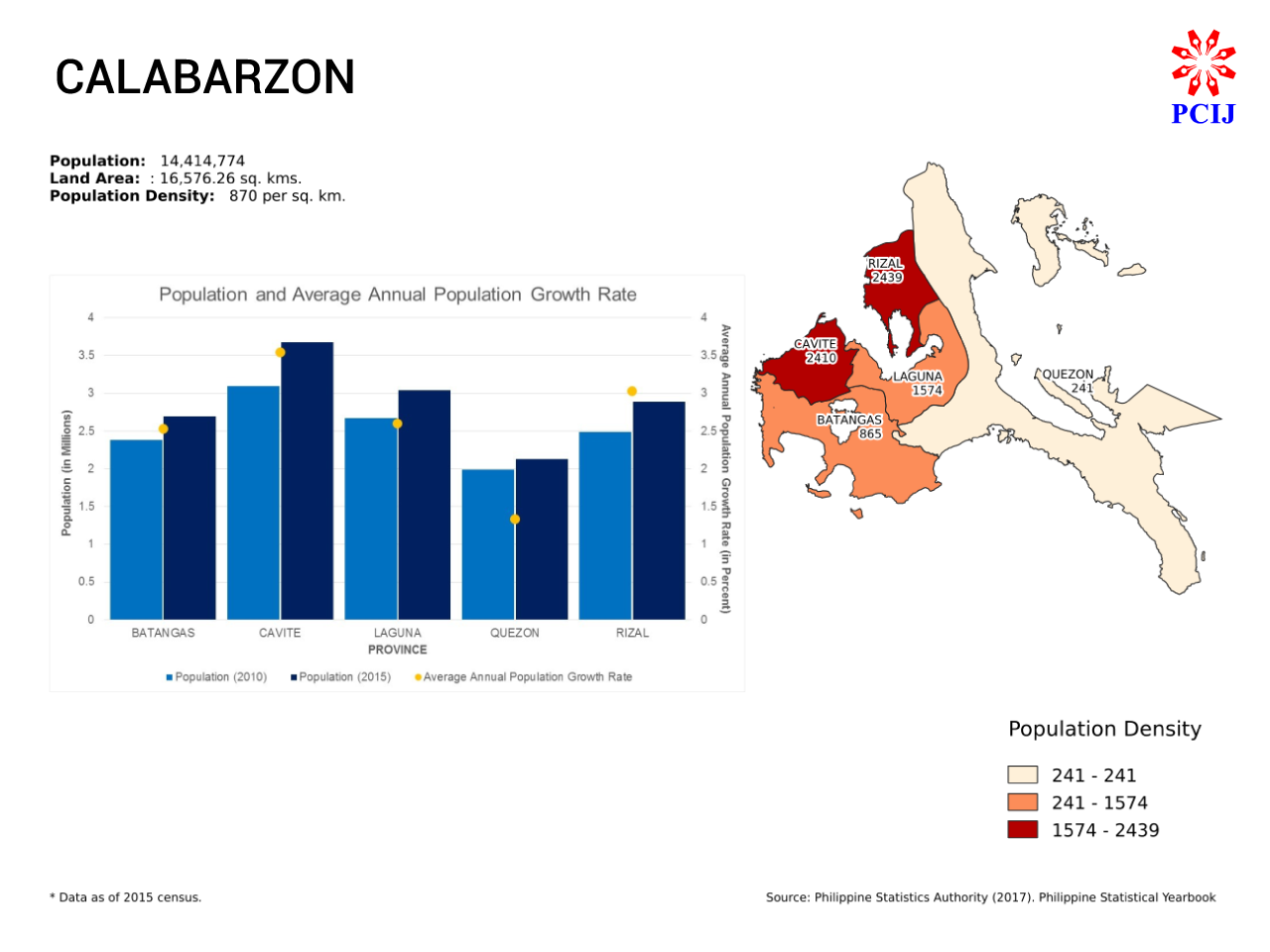
CALABARZON
Fast Facts (Rank among 18 regions):
Land Area: 16,576 sq km (No. 13)
Population: 14.41 million (No. 1)
Population density: 870 persons per sq km (No. 2)
The Federated Region of CALABARZON will comprise the current provinces in the current Region IV-A: Cavite, Laguna, Batangas, Rizal, and Quezon.
It will be the sixth smallest federated region in terms of land area, at 16,576 sq kms (4.77 percent of the country’s total land area), but the largest in terms of population, at 14,414,774 (14.27 percent of the country’s total population) as of POPCEN 2015. With a population density of 870 people per sq km (thrice the national population density), CALABARZON will be the second most densely populated federated region in the country, next to NCR.
The province of Quezon is the largest in CALABARZON in terms of land area, at 16,576.26 sq kms (53 percent of CALABARZON’s total land area), followed by Batangas at 3,115.05 km (19 percent), Laguna at 1,928.23 km (one percent), Cavite at1,526.28 sq kms (nine percent), and Rizal at 1,182.65 km (seven percent).
Cavite is the largest province in CALABARZON in terms of population, at 3,678,301 (26 percent of CALABARZON’s population) followed by Laguna at 3,035,081 (21 percent); Rizal at 2,884,227 (20 percent), Batangas at 2,694,335 (19 percent); and Quezon, at 2,122,830 (15 percent). Cavite and Laguna also rank third and fifth, respectively, among the provinces in the country in terms of population.
With a fifth of CALABARZON’s population living in just seven percent of its land area, Rizal ranks first in terms of population density, with 2,439 people per sq km, followed by Cavite at 2,410 people per sq km; Laguna at 1,574; and Batangas at 865 people.
With a land area covering more than half of CALABARZON and only 15 percent of the region’s population, the province of Quezon is the least densely populated in the region, at 241 people per sq km.
Cavite has the highest average annual population growth rate among the provinces in CALABARZON, with 3.54 percent, followed by Rizal at 3.03 percent; Laguna 2.6 percent; Batangas 2.53; and Quezon 1.33 percent.
Cavite ranks second, after Maguindanao, in terms of average annual population growth rate; Rizal ranks fourth, after Basilan.
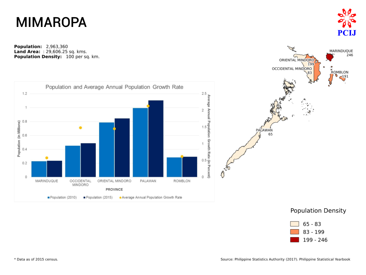
MIMAROPA
Fast Facts (Rank among 18 regions):
Land Area: 29,606 sq km (No. 2)
Population: 2.96 million (No. 17)
Population density: 100 persons per sq km (No. 17)
The Federated Region of MIMAROPA will comprise the provinces in the current Region IV-B: Occidental Mindoro and Oriental Mindoro, Marinduque, Romblon, and Palawan.
It will be the third largest federated region in terms of land area, with 29,606 sq kms (8.52 percent of the country’s total land area) but the third smallest in terms of population, with 2,596,709 (2.57 percent of the country’s total population) as of POPCEN 2015. With a population density of 100 people per sq km, MIMAROPA will be the second least densely populated region in the country, next to CAR.
Palawan is the largest province in MIMAROPA, as well as in the country, with a land area of 17,031 sq kms (58 percent of the region’s total land area). Occidental Mindoro ranks second largest in the region, at 5,851 sq kms (20 percent), followed by Occidental Mindoro at 4,238 sq kms (14 percent); Romblon 1,533 sq kms ( five percent); and Marinduque at 953 sq kms (three percent).
Palawan also has the largest population in MIMAROPA, with 1,104,585 people (37 percent of the region’s total population). It is followed by Oriental Mindoro with 844,059 (28 percent); Occidental Mindoro, with 487,414 (16 percent); Romblon, 292,781 (10 percent), and Marinduque with 234,521 (eight percent).
Marinduque is the most densely populated province in MIMAROPA, at 246 people per sq km, followed by Oriental Mindoro at 199 people per sq km; Romblon, 191;and Occidental Mindoro, 83.
With more than a quarter of the region’s total population living in nearly three-fifths of its land area, Palawan is the least densely populated province in MIMAROPA, at 65 people per sq km. Palawan is also tied with Kalinga and Mountain Province (in CAR) for being the third least densely populated provinces in the country.
Palawan has the highest average annual population growth rate among the provinces in MIMAROPA, at 2.13 percent, followed by Occidental Mindodo, 1.48 percent; Oriental Mindoro, 1.45 percent; Romblon, 0.62 percent; and Marinduque, 0.58 percent.
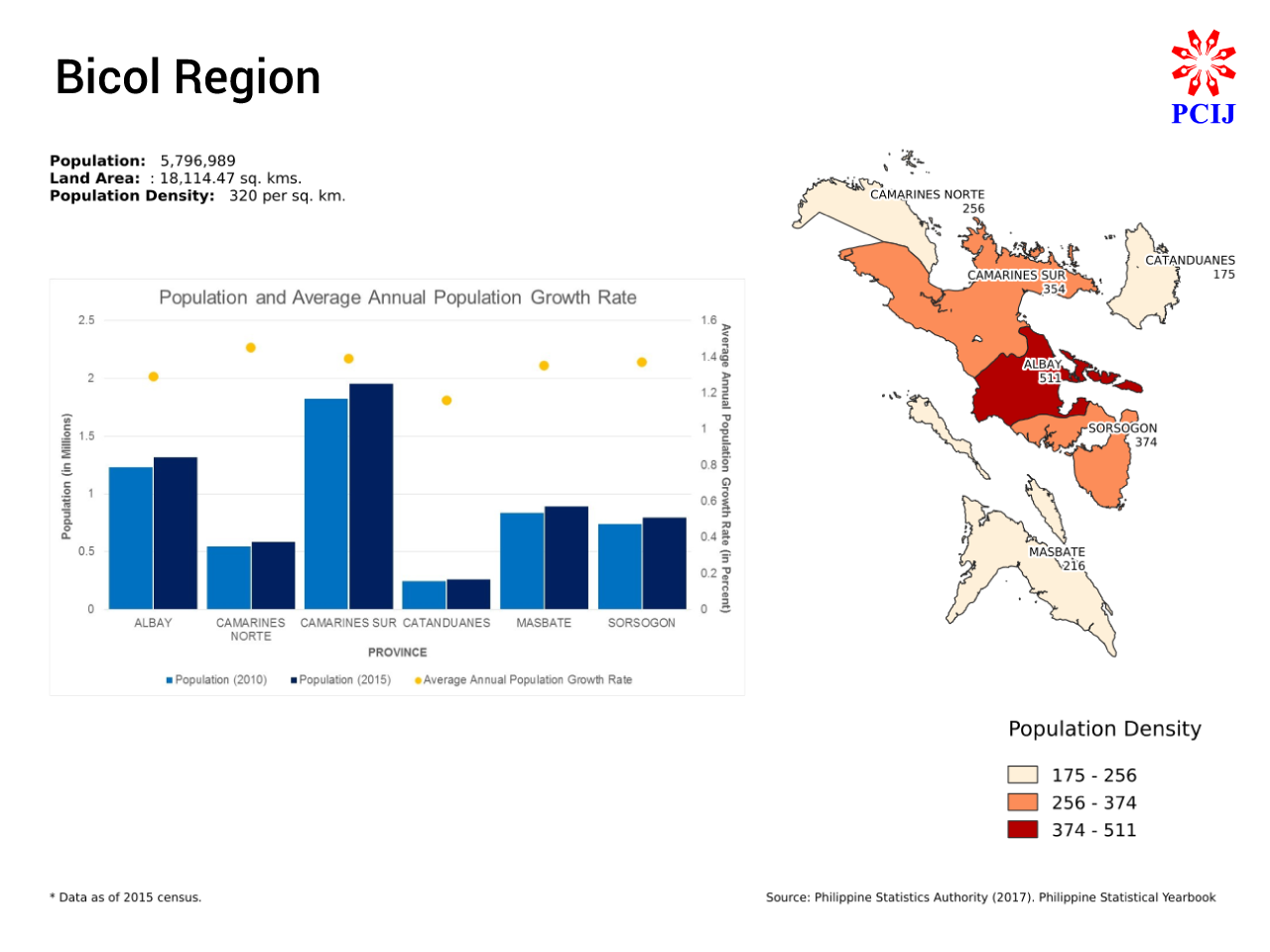
Bicol Region
Fast Facts (Rank among 18 regions):
Land Area: 18,114 sq km (No. 11)
Population: 5.80 million (No. 5)
Population density: 320 persons per sq km (No. 8)
The Federated Region of Bicol will comprise the provinces in the current Region V: Albay, Camarines Norte, Camarines Sur, Catanduanes, Masbate, and Sorsogon.
Bicol Region will be the eighth smallest federated region in terms of land area, at 18,114 sq kms (5.21 percent of the country’s total land area) and a population of 5,796,989 (5.74 percent of the country’s total population) as of POPCEN 2015. Bicol will rank eighth in terms of population density, at 320 people per sq km.
Camarines Sur is the largest province in Bicol in terms of land area, at 2,277.93 sq kms (30 percent of Bicol’s total land area), followed by Masbate at 4,139 sq kms (23 percent); Albay at 2,575 sq kms (14 percent); Camarines Norte at 2,278 sq kms (13 percent); Sorsogon at 2,119 sq kms (12 percent); and Catanduanes at 1,492 sq kms (eight percent).
Camarines Sur also has the largest population among the provinces in Bicol Region, with 1,952,544 people (34 percent of the region’s total population); followed by Albay with 1,314,826 (23 percent); Masbate, 892,393 (15 percent); Sorsogon, 792,949 (14 percent); Camarines Norte, 583,313 (10 percent); and Catanduanes, 260,964 (five percent).
Albay is the most densely populated province in Bicol, with 511 people per sq km, followed by Sorsogon with 374 people per sq km; Camarines Sur, 354; Camarines Norte, 256; Masbate, 216, and Catanduanes, 175.
Camarines Norte has the highest average annual population growth rate among the provinces in Bicol, at 1.45 percent, followed by Camarines Sur at 1.39 percent; Sorsogon, 1.37 percent; Masbate, 1.35 percent; Albay, 1.29 percent; and Catanduanes, 1.16 percent.
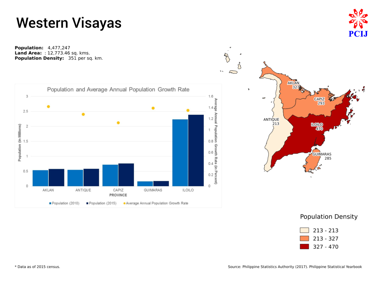
Western Visayas
Fast Facts (Rank among 18 regions):
Land Area: 12,773 sq km (No. 16)
Population: 4.48 million (No. 10)
Population density: 351 persons per sq km (No. 6)
The Federated Region of Western Visayas will comprise five of the six provinces in the current Region VI: Aklan, Antique, Capiz, Guimaras, and Iloilo.
It will be third smallest federated region in terms of land area, at 12,773 sq kms (3.67 percent of the country’s total land area) and the ninth smallest in terms of population, with 4,477,247 people (4.43 percent of the country’s total population). estern Visayas will rank sixth in terms of population density, at 351 people per sq km.
Iloilo will be the largest province in Western Visayas in terms of land area, at 5,076 sq kms (40 percent of the region’s total land area), followed by Antique at 2,731 sq kms (21 percent); Capiz, 2,595 (20 percent), and Aklan, 1,760 (14 percent). The island province of Guimaras is the smallest in Western Visayas and the fifth smallest in the country, with a land area of 612 sq kms (five percent of the region’s total land area).
Iloilo also has the largest population in Western Visayas, with 2,384,415 people (53 percent of the region’s total population), followed by Capiz with 761,384 (17 percent); Antique, 582,012 (13 percent) and Aklan, 574,823 (13 percent); and Guimaras, 174,613 ( four percent).
Iloilo is also the most densely populated province in the region, with 470 people per sq km, followed by Aklan, 327; Capiz, 293; Guimaras, 285; and Antique, 213.
Aklan has the highest average annual population growth rate among the provinces in Western Visayas, at 1.42 percent, followed by Guimaras at 1.39 percent; Iloilo, 1.35 percent; Antique, 1.28 percent; and Capiz, 1.13 percent.
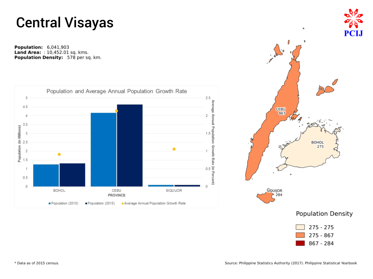
Central Visayas
Fast Facts (Rank among 18 regions):
Land Area: 10,452 sq km (No. 17)
Population: 6.04 million (No. 4)
Population density: 578 persons per sq km (No. 3)
The Federated Region of Central Visayas will have three of the four provinces in the current Region VII: Bohol, Cebu, and Siquijor.
Central Visayas will be the second smallest federated region in terms of land area, with 10,452 sq kms (3.01 percent of the country’s total land area), but the fourth largest in terms of population, with 6,041,903 people (5.98 percent of the country’s total population).With a population density of 578 people per sq km, Central Visayas will be the third most densely populated federated region in the country.
Cebu is the largest province in terms of land area, with 5,342 sq kms (51 percent of the region’s total land area) as well as population, with 4,632,359 people (77 percent of the region’s total population).
Cebu is also the most densely populated province in the region, with 867 people per sq km, and has the highest average annual population growth rate, at 2.14 percent. In addition, Cebu has the largest population among the country’s provinces.
Bohol comes second in terms of land area, with 4,772.52 sq kms (46 percent of the region’s total land area), as well as in population, with 1,313,560 people (22 percent of the region’s total population). It is, however, the least densely populated province, with 275 people per sq km, and has the lowest average annual growth rate in the region, at 0.91 percent.
Siquijor will be the smallest province in the region, with just 337.49 sq kms of land area (three percent of the region’s total land area), and in terms of population — 95,984 people or two percent of the region’s total population. Its population density is currently at 284 people per sq km and its average annual population growth rate is at 1.06 percent. Among the country’s smallest provinces, Siquijor ranks third in terms of land area.
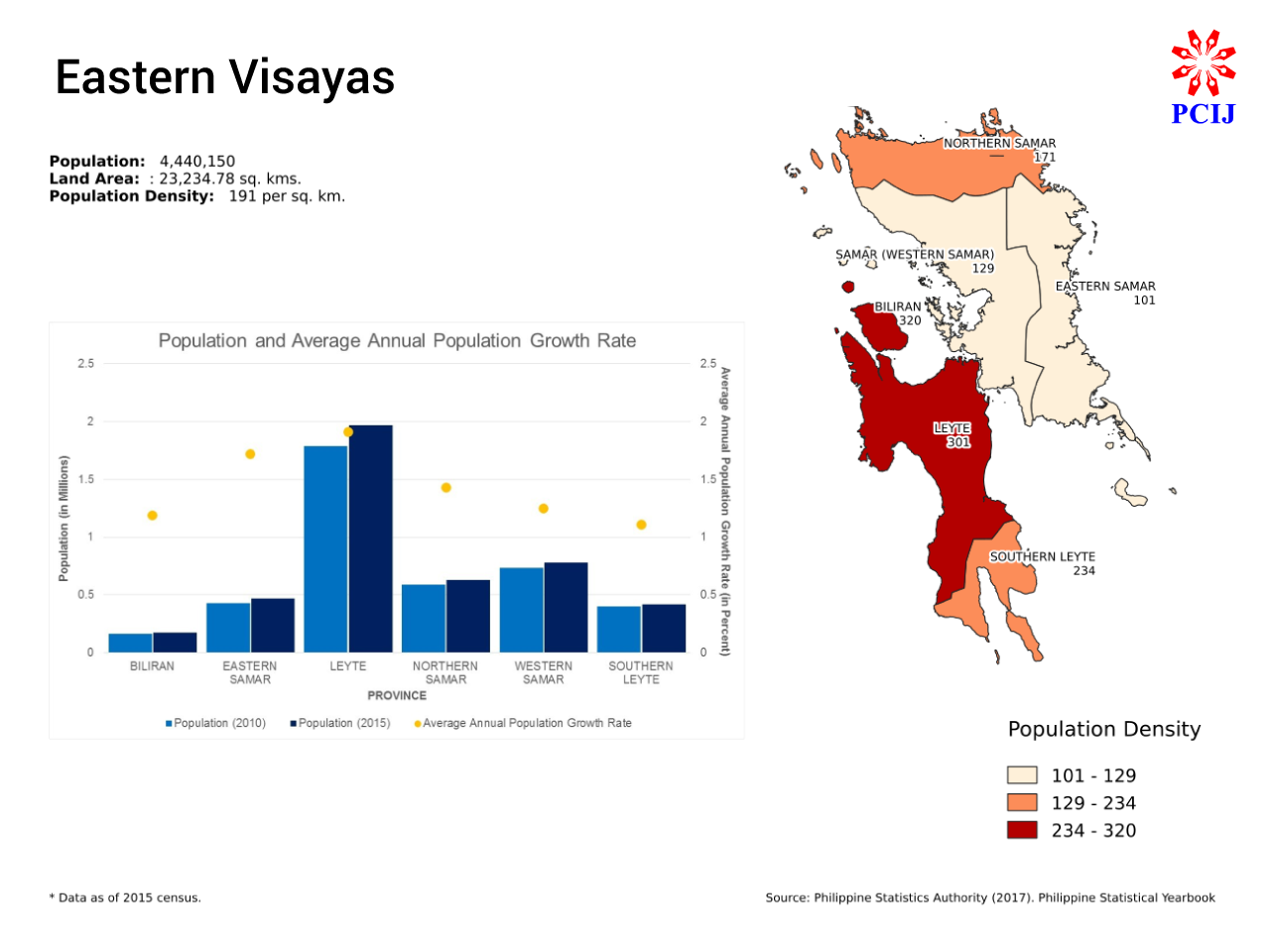
Eastern Visayas
Fast Facts (Rank among 18 regions):
Land Area: 23,234 sq km (No. 3)
Population: 4.44 million (No. 10)
Population density: 191 persons per sq km (No. 13)
Eastern Visayas will comprise the provinces of the current Region VIII: Eastern Samar, Northern Samar, Western Samar, Leyte, Southern Leyte, and Biliran.
It will be the fourth largest federated region in terms of land area, with 23,235 sq kms (6.68 percent of the country’s total land area), but the eighth smallest in terms of population, with 4,440,150 people (4.40 percent of the country’s total population). Eastern Visayas will rank 13th in terms of population density, at 191 people per sq km.
Leyte is the largest province in Eastern Visayas in terms of land area, with 6,537 sq kms (28 percent of the region’s total land area), followed by Western Samar with 780,481 sq kms (26 percent); Eastern Visayas, 4,617 sq kms (20 percent); Northern Samar, 3,695 sq kms (16 percent), and Southern Leyte, 1,801 sq kms (eight percent). The island province of Biliran is the smallest in the region, as well as the fourth smallest in the country, with a land area of 536 sq kms.
Leyte also has the largest population among the provinces in Eastern Visayas, with 1,966,768 people (44 percent of the region’s total population), followed by Western Samar with 780,481 (18 percent); Northern Samar, 632,379 (14 percent); Eastern Samar, 467,160 (11 percent); Southern Leyte, 421,750 (nine percent); and Biliran, 171,612 (four percent).
Biliran is the most densely populated province with 320 people per sq km, followed by Leyte with 301 people per sq km; Southern Leyte, 234; Northern Samar, 171; Western Samar, 129; and Eastern Samar, 101.
Leyte has the highest average annual population growth rate among the provinces in Eastern Samar, at 1.91 percent, followed by Eastern Samar at 1.72 percent; Northern Samar, 1.43 percent; Western Samar, 1.25 percent; Biliran, 1.19 percent; and Southern Leyte, 1.11 percent.
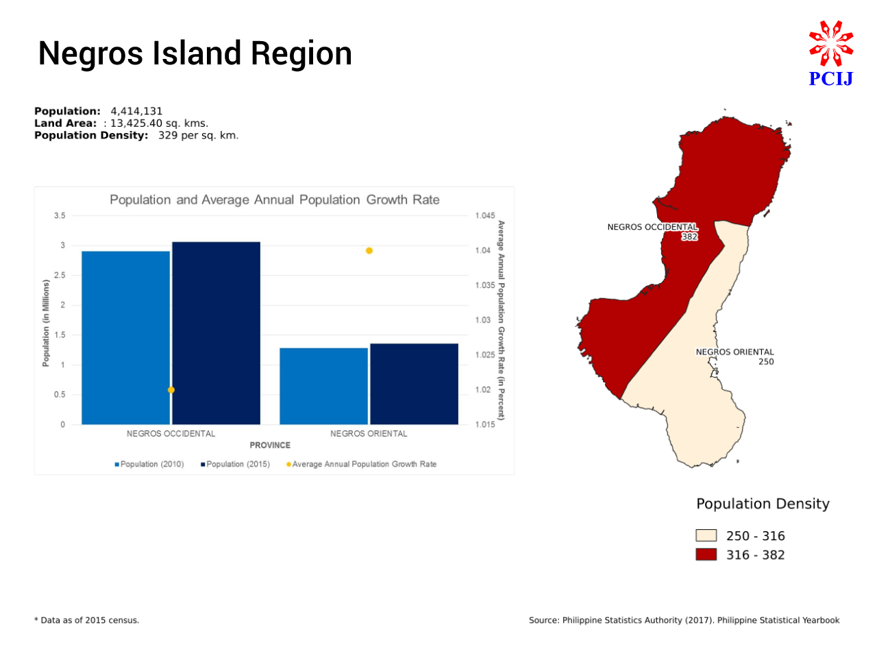
Negros Island Region
Fast Facts (Rank among 18 regions):
Land Area: 13,425 sq km (No. 14)
Population: 4.41 million (No. 12)
Population density: 329 persons per sq km (No. 7)
The Federated Region of Negros Island (NIR) will comprise the provinces of Negros Occidental (currently in Region VI) and Negros Oriental (currently in Region VII).
Then President Benigno S. Aquino III’s Executive Order No. 183 actually created NIR in 2015, but this was suspended by President Rodrigo R. Duterte’s EO 83 in 2016.
NIR will be the fifth smallest among the proposed federated regions in terms of land area, with 13,425.4 sq kms (4.48 percent of the country’s total land area) and the seventh smallest in terms of population, with 4,414,313 people (4.37 percent of the country’s total population). It will rank seventh in terms of population density, at 329 people per sq km.
Negros Occidental is the larger of the two Negros provinces, with a land area of 8,005 sq kms and population of 3,059,136 (the fourth largest in the country). It also has the higher population density, at 382 people per sq km, but has the lower average annual growth rate, at 1.02 percent.
Negros Oriental has a land area of 5,421 sq kms, a population of 1,354,995, a population density of 250 people per sq km, and an average annual growth rate of 1.04 people.

Zamboanga Peninsula
Fast Facts: (Rank among 18 regions)
Land Area: 16,576 sq km (No. 13)
Population: 3.63 million (No. 14)
Population density: 215 persons per sq km (No. 11)
The Federated Region of Zamboanga Peninsula will comprise the provinces in the current Region IX — Zamboanga del Norte, Zamboanga del Sur, and Zamboanga Sibugay — as well as the component city of Isabela in the province of Basilan (part of ARMM).
It will be the seventh smallest region in terms of land area, with 16,904 sq kms (4.86 percent of the country’s total land area) and fifth smallest in terms of population, with 3,629,783 people (3.59 percent of the country’s total population). Zamboanga Peninsula will rank 11th in terms of population density, with 215 people per sq km.
Zamboanga del Norte will be the region’s largest province in terms of land area, with 7,300 sq kms (43 percent of the region’s total land area), followed by Zamboanga del Sur with 5,899 sq kms (35 percent), and Zamboanga Sibugay at 3,481 sq kms (21 percent). The component city of Isabela has a land area of 224 sq kms.
Zamboanga del Sur has the largest population, with 1,872,473 people (52 percent of the region’s total population), followed by Zamboanga del Norte with 1,011,393 (28 percent); and Zamboanga Sibugay with 633,129 (17 percent). Isabela City has a population of 112,788 (three percent of the region’s population) as of POPCEN 2015.
With more than half of the region’s population living in a third of its land area, Zamboanga del Sur is also the most densely populated province in Zamboanga Peninsula, at 317 people per sq km, followed by Zamboanga Sibugay at 182 people per sq km, and Zamboanga del Norte, at 139 people per sq km. Isabela City has a population density of 504 people per sq km, almost twice of the regional average.
Zamboanga Sibugay has the highest average annual population growth rate among the provinces in Zamboanga Peninsula, at 1.65 percent, followed by Zamboaga del Sur at 1.17 percent and Zamboanga del Norte at 1.09 percent. Isabela City, however, beats them all with its average annual population growth rate of 2.88 percent.
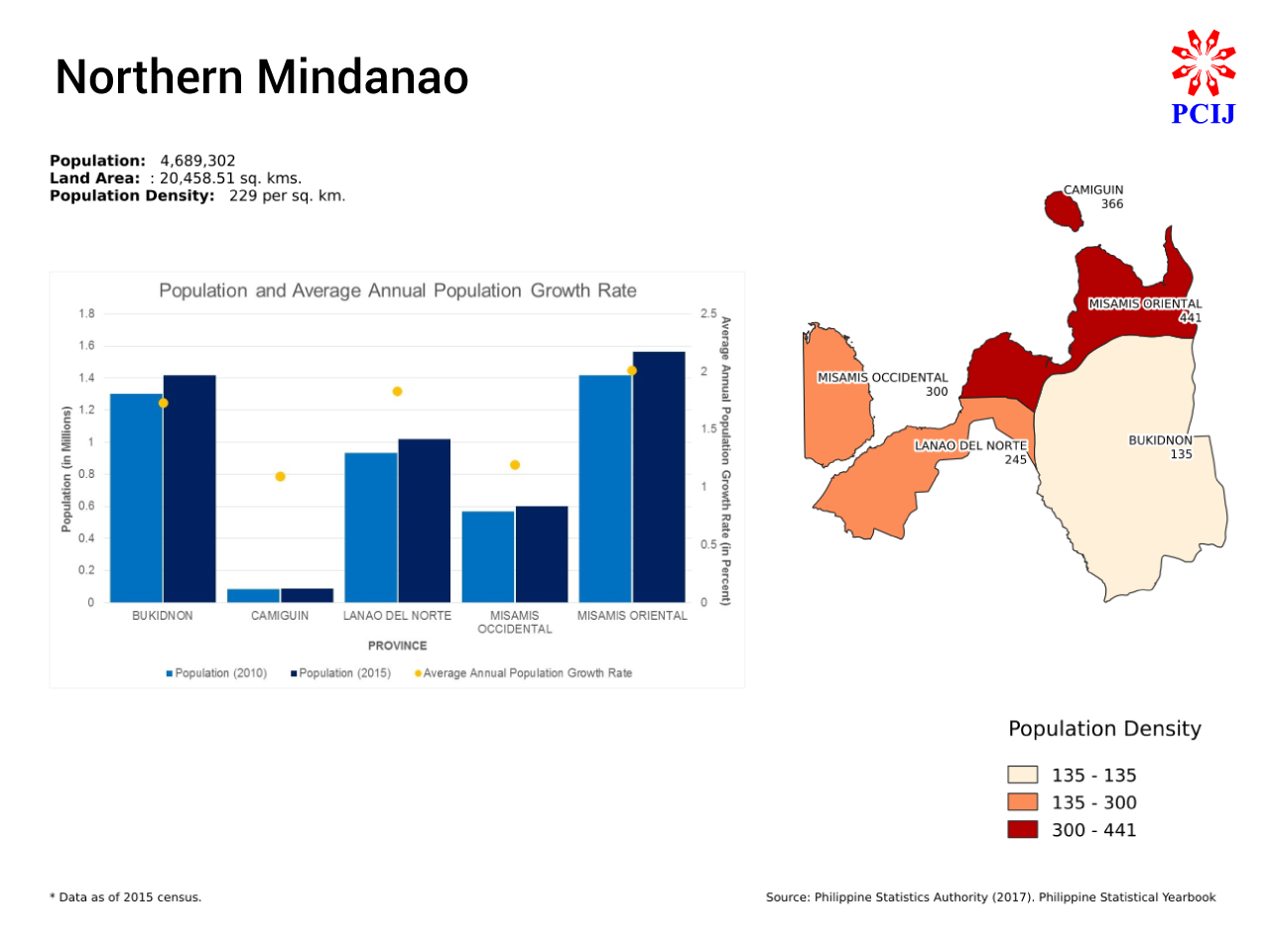
Northern Mindanao
Fast Facts: (Rank among 18 regions)
Land Area: 20,458 sq km (No. 8)
Population: 4.69 million (No. 9)
Population density: 229 persons per sq km (No. 10)
The Federated Region of Northern Mindanao will comprise the provinces of the current Region X, namely, Bukidnon, Camiguin, Lanao del Norte, Misamis Occidental, and Misamis Oriental.
It will be the eighth largest federated region in terms of land area, with 20,459 sq kms (5.88 percent of the country’s total land area) and population, with 4,689,302 people (4.64 percent of the country’s total population). Northern Mindanao will rank 10th in terms of population density, at 229 people per sq km.
Bukidnon is the largest province in Northern Mindanao in terms of land area, at 10,498.59 sq kms (51 percent of the region’s total land area), followed by Lanao del Norte at 4,168 sq kms (20 percent), Misamis Oriental at 3,544 sq kms, and Misamis Occidental at 2,007 sq kms.
The island province of Camiguin is the smallest in the region, and second smallest in the country, in terms of land area, at 241.44 sq kms (one percent of the region’s total land area).
Misamis Oriental has the largest population, with 1,564,459 people (33 percent of the region’s total population), followed by Bukidnon, 1,415,226 (30 percent); Lanao del Norte, 1,019,013 (22 percent); and Misamis Occidental, 602,126 (13 percent). Camiguin has the smallest population among the provinces in the region, and the second smallest in the country, with 88,478 people as of POPCEN 2015.
Misamis Oriental is also the most densely populated province in the region, with 441 people per sq km, followed by Camiguin at 366 people per sq km; Misamis Occidental,300 people per sq km; and Lanao del Norte, 245 people per sq km. With 30 percent of the region’s total population living in more than half its land area, Bukidnon is the least densely populated province in the region, with 135 people per sq km.
Misamis Oriental has the highest average annual population growth rate – 2.01 percent — among the provinces in the region as well, followed by Lanao del Norte with 1.83 percent, Bukidnon 1.73 percent; Misamis Occidental 1.19 percent; and Camiguin 1.09 percent.
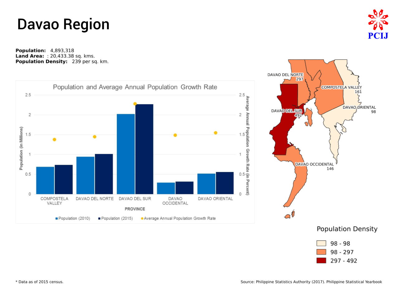
Davao Region
Fast Facts: (Rank among 18 regions)
Land Area: 20,433 sq km (No. 9)
Population: 4.89 million (No. 7)
Population density: 239 persons per sq km (No. 9)
The Federated Region of Davao will comprise the provinces of current Region XI: Compostela Valley, Davao del Norte, Davao del Sur, Davao Oriental, and Davao Occidental.
It will be the ninth largest federated region in terms of land area, with 20,433 sq kms (5.88 percent of the country’s total population), and seventh largest in terms of population, with 4,893,318 people (4.85 percent of the country’s total population). Davao will rank ninth in terms of population density, at 240 people per sq km.
Davao Oriental is the largest province in the proposed federated region of Davao in terms of land area, with 5,679.64 sq kms (28 percent of the region’s total land area), followed by Davao del Sur with 4,608 sq kms (23 percent); Compostela Valley, 4,560 sq kms (22 percent); Davao del Norte, 3,423 sq kms (17 percent); and Davao Occidental, 2,163 sq kms (11 percent).
Davao del Sur has the largest population among the provinces in Davao Federated Region, with 2,265,579 people (46 percent of the region’s total population), followed by Davao del Norte with 1,016,332 (21 percent); Compostela Valley with 736,107 (15 percent); Davao Oriental 558,958 (11 percent); and Davao Occidental 316,342 (six percent).
Davao del Sur is also the most densely populated province in the region, with 492 people per sq km, followed by Davao del Norte with 297 people per sq km; Compostela Valley with 161; Davao Occidental 146; and Davao Oriental 98.
Davao del Sur also has the highest average annual population growth rate among the provinces in Davao, at 2.28 percent, followed by Davao Oriental at 1.55 percent; Davao Occidental at 1.49 percent; Davao del Norte at 1.45 percent; and Compostela Valley at 1.38 percent.
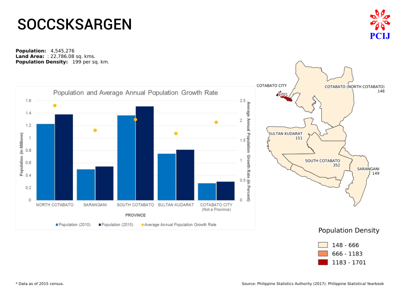
SOCCSKSARGEN
Fast Facts: (Rank among 18 regions)
Land Area: 22,786 sq km (No. 5)
Population: 4.55 million (No. 9)
Population density: 199 persons per sq km (No. 12)
The Federated Region of SOCCSKSARGEN will comprise the current provinces of Region X: South Cotabato, North Cotabato. Sultan Kudarat, Sarangani, and the independent component city of Cotabato in the province of Maguindanao (currently part of ARMM).
It will be the fifth largest federated region in terms of land area, with 22,786 sq kms (6.55 percent of the country’s total land area) and ninth largest in terms of population, at 4,545,276 (4.50 percent of the country’s total population). SOCCSKSARGEN ranks 12th in terms of population density, at 199 people per sq km.
North Cotabato is the largest province in SOCCSKSARGEN in terms of land area, with 9,317.3 sq kms (41 percent of the region’s total land area), followed by Sultan Kudarat with 5,364 sq kms (24 percent); South Cotabato with 4,287 sq kms (19 percent); and Sarangani, 3,642 sq kms. Cotabato City, meanwhile, has a land area of 176 sq kms or one percent of the region’s total land coverage.
South Cotabato has the largest population among the provinces in SOCCSKSARGEN, with 1,509,735 people (33 percent of the region’s total population), followed by North Cotabato with 1,379,747 (30 percent); Sultan Kudarat 812,095 (18 percent); and Sarangani 544,261 (12 percent). Cotabato City has a population of 299,438 or seven percent of the proposed region’s total number of people.
South Cotabato has the highest population density among SOCCSKSARGEN’s provinces, with 352 people per sq km, followed by Sultan Kudarat with 151; Sarangani 149; and North Cotabato 148. Cotabato City’s population density of 1,701 people per sq km is more than eight times that of the regional average.
North Cotabato has the highest average annual population growth rate among the provinces in SOCCSKSARGEN, at 2.38 percent, followed by South Cotabato at 2.03 percent, Cotabato City at 1.96 percent, Sarangani at 1.76 percent, and Sultan Kudarat at 1.68 percent.
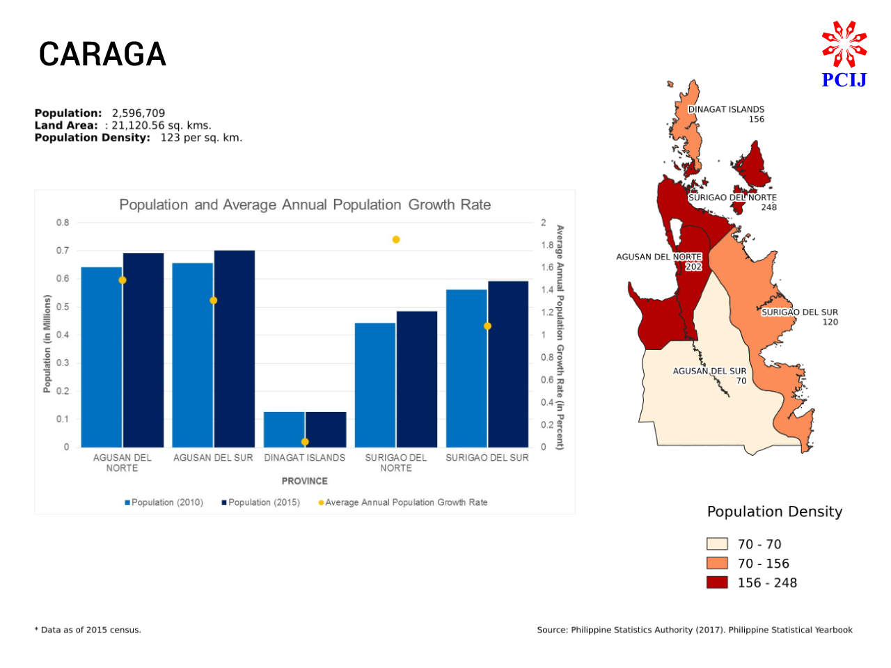
Caraga Region
Fast Facts: (Rank among 18 regions)
Land Area: 29,606 sq km (No. 2)
Population: 2.60 million (No. 16)
Population density: 123 persons per sq km (No. 14)
The Federated Region of Caraga will comprise the current provinces of Region XIII: Agusan del Norte, Agusan del Sur, Surigao del Norte, Surigao del Sur, and the Dinagat Islands.
It will be the seventh largest federated region in terms of land area, with 21,121 sq kms or 6.07% of the country’s land area, but the second smallest in terms of population, with 2,596,709 people (2.57 percent of the country’s total population). Caraga will rank 14th in terms of population density, at 123 people per sq kms as of POPCEN 2015.
Agusan del Sur will be the largest province in Caraga, and the fifth largest in the country, in terms of land area, with 9,989 sq kms (47 percent of the Caraga’s total land area), followed by Surigao del Sur with 4,933 sq kms (23 percent); Agusan del Norte with 3,428 sq kms (16 percent); Surigao del Norte with 1,953 sq kms (nine percent), and the Dinagat Islands with 817 sq kms (four percent).
Agusan del Norte, however, has the largest population among the provinces in Caraga, with 700,653 people (27 percent of Caraga’s total population), followed closely by Agusan del Sur with 691,566 (27 percent); Surigao del Sur with 592,250 (23 percent; and Surigao del Norte with 485,088 (19 percent). The Dinagat islands group has the smallest population among the provinces in Caraga, and the fifth smallest in the country, with 127,152 people.
With almost a fifth of the Caraga’s total population living in a tenth of its land area, Surigao del Norte is the most densely populated province in the region, with 248 people per sq km, followed by Agusan del Norte with 202 people per sq km; Dinagat Islands with 156; and Surigao del Sur with 120. Meanwhile, with more than a quarter of the region’s total population living in nearly half of its land area, Agusan del Sur comes in as the least densely populated province in Caraga, with 70 people per sq km.
Surigao del Norte has the highest average annual population growth rate among the provinces in Caraga, at 1.85 percent, followed by Agusan del Norte at 1.49 percent, Agusan del Sur at 1.31 percent, and Surigao del Sur at 1.08 percent. Dinagat Islands has the lowest average annual population growth rate in the region, and ties with Apayao for having the lowest in the country, at 0.05 percent.

Autonomous Region in Muslim Mindanao
Fast Facts: (Rank among 18 regions)
Land Area: 36,650 sq km (No. 1)
Population: 3.78 million (No. 13)
Population density: 103 persons per sq km (No. 16)
The Autonomous Region in Muslim Mindanao (ARMM) will comprise the provinces of Basilan (excluding the component city of Isabela), Lanao del Sur, Maguindanao (excluding the independent component city of Cotabato), Sulu, and Tawi-Tawi.
It will be the largest federated region in terms of land area, with 36,651 sq kms (10.54 percent of the country’s total land area), but the sixth smallest in terms of population, with 3,781,387 (3.74 percent of the country’s total population). With a population density of just 103 people per sq km, ARMM will be the third least densely populated federated region, as of POPCEN 2015.
Lanao del Sur is the largest province in ARMM, and the second largest in the country, in terms of land area, with 15,056 sq kms (41 percent of ARMM’s total land area). Maguindanao ranks second with 9,968 sq kms (27 percent), followed by Sulu with 4,547 sq kms (12 percent), Tawi-Tawi with 3,627 sq kms (10 percent), and Basilan with 3,453 (nine percent).
Maguindanao, though, has the largest population in ARMM, with 1,173,933 people (31 percent of ARMM’s total population). It is followed by Lanao del Sur with 1,045,429 (28 percent), Sulu with 824,731 (22 percent), Tawi-Tawi with 390,715 (10 percent), and Basilan at 346,579 ( nine percent) as of POPCEN 2015.
Sulu is the most densely populated province in ARMM, with 181 people per sq km, followed by Maguindanao with 118, Tawi-Tawi with 108, and Basilan with 100. Lanao del Sur is the least densely populated province in the region, with 69 people per sq km.
The provinces in ARMM have some of the highest average annual population growth rates in the country, notably Maguindanao (highest average annual population growth rate in the region and in the country) at 4.44 percent, followed by Basilan at 3.39 percent (third highest in the country), Sulu at 2.8 percent (fifth highest in the country), and Lanao del Sur at 2.3 percent. Tawi-Tawi has the lowest average annual population growth rate in the region, at 1.29 percent. — PCIJ, July 2018
—————————————————————-
To browse more data on the Philippines across periods of time, visit PCIJ’s MoneyPolitics Online.